


www.EducationDx.com

GPS for Surveying Land


Hit the button below when you find a GPS handheld you like or want more information about. >>Read the customer reviews of the effectiveness of the product before purchasing!

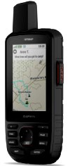
-Enable two-way messaging and location tracking via the 100% global Iridium satellite network, and trigger an interactive SOS to Garmin Response℠, a 24/7 staffed emergency response coordination center
Garmin GPSMAP 67i Rugged GPS Handheld with inReach® Satellite Technology

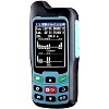
BEVA GPS Land Measuring Instrument
-Mini Handheld GPS Units for Mountainous Land, Slope and Flat Field
MULTIPLE MEASUREMENT FEATURES:
-GPS area measuring tool of any shape (mountainous land, slope and flat field),and measure length of any shape (straight line,curve; figure track and automatically calculate price measurement.
-GPS area measuring tool of any shape (mountainous land, slope and flat field),and measure length of any shape (straight line,curve; figure track and automatically calculate price measurement.
Sponsored Link
Surveying Your Property with a Handheld GPS
Are you trying to find the property lines on your land, but don't want to pay the costs of hiring a professional surveyor? Nobody wants to spend money on something you can't see, but other than the paper that you may need legally, maybe you just want to see where those old "buried" property pins are located.
Over the years the pins may have been destroyed by the weather (e.g., rust), construction crews installing sewer, water or gas lines (in the right-of-way or on your property), or by an unfriendly neighbor or michievous child.
A word of caution: Many GPS devices can get you "close" to the actual property boundaries, but a professional surveyor, whose equipment cost thousands of dollars, might be the way to go if you want a precise measurement and a legal document.
Another thing to consider is what the reviewers who actually bought the device have to say. Read the reviews before buying. Look at the percentages, because some may have purchased a "lemon" or just bought the wrong device.
Also, can you get all the feature$ you want within your budget? Only selecting the features you need should reduce the price.


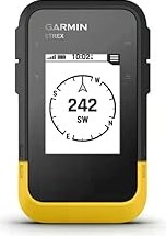
Garmin eTrex® SE GPS Handheld Navigator
-Multi-GNSS support gives access to multiple global navigation satellite systems (GPS, GLONASS, Galileo, BeiDou and QZSS) to track in more challenging environments than GPS alone
-Plot your bearing with the digital compass, which provides an accurate heading even when stationary
-Plot your bearing with the digital compass, which provides an accurate heading even when stationary

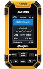
Land Surveying Machine
-Professional GNSS Receiver GPS Land Meter with Color Screen for Area Measurement
-8 area measurement modes: Normal mode, mountain mode, intelligent slope mode, length and width mode, fixed width mode, fixed point mode, circle machine load, round-trip machine load.
-8 area measurement modes: Normal mode, mountain mode, intelligent slope mode, length and width mode, fixed width mode, fixed point mode, circle machine load, round-trip machine load.
Product Samples


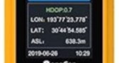

High Precision Handheld GPS Survey Equipment Land Area Meter
-Vehicle Measure Mode, help you solve all kinds of terrain area measurement. -This multifunction land area meter can you automatically calculation different shapes of area and also for curve line distance measurement. Slope mode, which can measure a slope height and angle.

An Introduction to GPS Real Time Kinematic Topographic Survey Procedures (Land Surveying)
Paperback Book
An Introduction to GPS Real Time Kinematic Topographic Survey Procedures (Land Surveying)
An Introduction to GPS Real Time Kinematic Topographic Survey Procedures (Land Surveying)
-An introductory technical guidance for civil engineers, land surveyors and construction managers interested in learning about GPS real time kinematic procedures for topographic surveys.
*Disclosure: The “Check Amazon Link” buttons on this website are associate links and are used to help illustrate what an item looks like, and you can decide if you want to just look or purchase the item. "As an Amazon Associate, I earn from qualifying purchases." We receive a small commission (that helps support this website) if you actually purchase from this company, but the price to you remains the same.
You can hover over any link to see if it is an Amazon link, if this matters, or a link to a page on this website or to a reference page, e.g., Smithsonian Institution, bookmark on this website, etc.
You can hover over any link to see if it is an Amazon link, if this matters, or a link to a page on this website or to a reference page, e.g., Smithsonian Institution, bookmark on this website, etc.

EducationDx ©2024


This is a FREE information site!
www.EducationDx.com
Note: Larger computer screens will show larger materials!
GPS for Surveying Land
Product Samples
Surveying Your Property with a Handheld GPS
Are you trying to find the property lines on your land, but don't want to pay the costs of hiring a professional surveyor? Nobody wants to spend money on something you can't see, but other than the paper that you may need legally, maybe you just want to see where those old "buried" property pins are located.
Over the years the pins may have been destroyed by the weather (e.g., rust), construction crews installing sewer, water or gas lines (in the right-of-way or on your property), or by an unfriendly neighbor or michievous child.

Sponsored Link

A word of caution: Many GPS devices can get you "close" to the actual property boundaries, but a professional surveyor, whose equipment cost thousands of dollars, might be the way to go if you want a precise measurement and a legal document.
Another thing to consider is what the reviewers who actually bought the device have to say. Read the reviews before buying. Look at the percentages, because some may have purchased a "lemon" or just bought the wrong device.
Also, can you get all the feature$ you want within your budget? Only selecting the features you need should reduce the price.


MULTIPLE MEASUREMENT FEATURES:
-GPS area measuring tool of any shape (mountainous land, slope and flat field),and measure length of any shape (straight line,curve; figure track and automatically calculate price measurement.
-GPS area measuring tool of any shape (mountainous land, slope and flat field),and measure length of any shape (straight line,curve; figure track and automatically calculate price measurement.
-Mini Handheld GPS Units for Mountainous Land, Slope and Flat Field
BEVA GPS Land Measuring Instrument


-Professional GNSS Receiver GPS Land Meter with Color Screen for Area Measurement
-8 area measurement modes: Normal mode, mountain mode, intelligent slope mode, length and width mode, fixed width mode, fixed point mode, circle machine load, round-trip machine load.
-8 area measurement modes: Normal mode, mountain mode, intelligent slope mode, length and width mode, fixed width mode, fixed point mode, circle machine load, round-trip machine load.
Land Surveying Machine

Garmin eTrex® SE GPS Handheld Navigator
-Multi-GNSS support gives access to multiple global navigation satellite systems (GPS, GLONASS, Galileo, BeiDou and QZSS) to track in more challenging environments than GPS alone
-Plot your bearing with the digital compass, which provides an accurate heading even when stationary
-Plot your bearing with the digital compass, which provides an accurate heading even when stationary
-Vehicle Measure Mode, help you solve all kinds of terrain area measurement. -This multifunction land area meter can you automatically calculation different shapes of area and also for curve line distance measurement. Slope mode, which can measure a slope height and angle.
High Precision Handheld GPS Survey Equipment Land Area Meter


Garmin GPSMAP 67i Rugged GPS Handheld with inReach® Satellite Technology
-Enable two-way messaging and location tracking via the 100% global Iridium satellite network, and trigger an interactive SOS to Garmin Response℠, a 24/7 staffed emergency response coordination center
Paperback Book
An Introduction to GPS Real Time Kinematic Topographic Survey Procedures (Land Surveying)
An Introduction to GPS Real Time Kinematic Topographic Survey Procedures (Land Surveying)

An Introduction to GPS Real Time Kinematic Topographic Survey Procedures (Land Surveying)
-An introductory technical guidance for civil engineers, land surveyors and construction managers interested in learning about GPS real time kinematic procedures for topographic surveys.
*Disclosure: The “Check Amazon Link” buttons on this page are associate links and are used to provide more details about an item, and you can decide if you want to just look or purchase the item. "As an Amazon Associate, I earn from qualifying purchases." We receive a small commission (that helps support this website) if you actually purchase from this company, but the price to you remains the same.
EducationDx
©2024
©2024

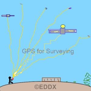
DIY GPS Surveying
DIY GPS Surveying
How does it work?
How does it work?